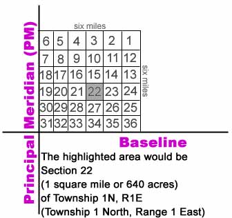
The Rectangular Survey or Grid System was setup by the Bureau of Land Management (BLM) in order to simplify the division of land so that it could be sold. An imaginary grid was placed on the area west of the Ohio River. Baselines and Principal Meridians (PM) were set and 34 survey meridian areas were measured. The area was set to include a tract of land measuring 24 miles by 24 miles. Each tract of land was then divided into 16 townships. Townships were divided into sections.BASELINE: Baseline is an imaginary east-west line and is used as the starting point of measurement in both directions. S would denote the land tract falls South of the line, N denotes the area falls North of the line. All parcels of land in Manitowoc County are North of the baseline. MERIDIAN: Meridian or Principal Meridian (PM) is the term for the imaginary north-south line used as the starting point of measurement of areas east or west of the line. Range numbers are given based on the vicinity of the area to the principal meridian. E would denote the area of land that falls East of the line and W would denote the area falls West of the line. The early PM's were numbered, the later ones were labeled based on a geographic landmark. The Principal Meridian on which Manitowoc County is measured is the 4th PM established in 1831 Minnesota/Wisconsin. All parcels of land in Manitowoc County are East of the PM. TOWNSHIP: A township is an area of land containing 6 square miles or approximately 23,040 acres. Each township was divided into 36 sections (as seen in Figure 1 above). Townships were given a number which indicated the direction of the township to the horizontal baseline (north or south). Not all townships are exactly square. Every few rows of townships there is a "jog" in the meridian because of the curve of the earth. Also due to geological formations, some townships are smaller. For example, the township where Two Creeks is located does not have certain sections numbers because the sections are in the area covered by Lake Michigan. Beginning at the southern county line, Manitowoc townships are numbered No. 17N, 18N, 19N, 20N, or 21N respectively. TOWN: Town is the given name of an area established within an area (most often a county). Towns may or may not have the same boundary lines as a township. A town can cross over into several townships. The word town and township are often interchanged.
Figure 1
RANGE: Range Number indicates the direction and distance of the township in relationship to the principal meridian (east or west). Manitowoc County consists of ranges R21E, R22E, R24E, or R25E.
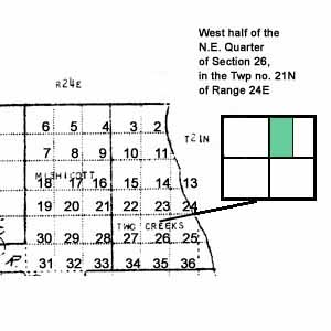
SECTION: A section is an area of land within a township. It is about 1 square mile containing approximately 640 acres each. The sections of a township are numbered as seen in Figure 1 above. Sections are then divided into half-sections and quarter-sections. Half-sections and quarter-sections could be divided and further subdivided into halves and quarters or into lots. LOT: A lot is a fractional or odd shaped portion of land falling within a section. If a lot is included in a description of land, it will be denoted as a one- or two-digit number and may include a lower case alphabet. For example, "Lot 12a of the north-west quarter" is denoted as "12aNW" in the description. IN GENERAL: Township: 23,040 acres Section: 640 acres Half section: 320 acres Quarter section: 160 acres Half of a quarter section: 80 acres A quarter of a quarter: 40 acres Thus a land description such as: West half of the N.E. Quarter of Section 26, in the Twp no. 21N of Range 24E in Manitowoc County, WI Would be 80 acres of land located in Two Creeks as shown below.